Marlinton, West Virginia - The Triple Lindy
Overview
Jay Walls and I started planning this adventure when we were bikepacking over five days from Abingdon to Covington in the Virginia mountains this past June. We always discuss what is next and we both wanted to try multiple overnighters from a central location that we could use as a “home base” so to speak. We both love the Marlinton, West Virginia area so I took the challenge to develop a six day or so adventure. I’m pretty familiar with the area as I’ve spent a lot of time in Pocohantas County since the late 70’s. We knew we wanted to spend a night on the Cranberry River and we were also interested in spending a night on Bald Knob, which is the second highest peak in West Virginia. Bald Knob has been a target for few years since we got inspiration to tackle it from Andy Forron who owns New River Bikes in Fayetteville, WV. Andy has provided a lot of guidance about riding in West Virginia over the past few years and when he talked about staying at the top of Bald Knob and showed us some of the incredible pictures he took, I knew at some point I was going to have to take that challenge. The final overnight route was just looking at something to the southeast of Marlinton and trying to make a rideable loop. There weren’t many options but there was one old country road on my Monongahela National Forest map southeast of Watoga State Park that looked like it would allow us to connect into the Anthony Creek area and then ride back to Marlinton on the Greenbrier River Trail. If you are familiar with National Forest Maps, some of the roads are outlined with dashed lines, which indicates that they are not maintained and their condition could be anywhere from decent to non-existent. I tried to follow it on Google Maps and Google Earth, but I couldn’t get a feel for what type of shape it was in, especially in the middle as the tree cover was too dense to see the road. I even looked at heat maps on Ride with GPS and Strava and noticed that there were a couple of folks who had ridden the road but not many. Maybe this was a warning?
Anyway, sometimes you can’t fully scout everything so you just go for it. We set our dates for mid-September and made three overnight routes out of Marlinton that we planned to ride over six or seven days. We decided to use the Old Clark Inn as our home base. The Old Clark Inn is under new ownership, and they were very accommodating allowing us to leave Jay’s truck at the Inn and also allowing us to do laundry each time we returned to the Inn. They always have cold beer in the refrigerator waiting for you when you arrive, which is a huge bonus after a couple of days of riding in the backcountry. We also had a float/rest day available if we wanted to relax and maybe see some of the sights in the area.
So with three loops, I thought the natural name for this adventure should be The Triple Lindy in honor of Rodney Dangerfield’s cinematic masterpiece Back To School, where he does an amazing triple loop dive to win a college swim meet. If you haven’t seen it, you must watch it as this is certainly his best lead role in a movie.
We had our plan and were excited to explore the Monongahela National Forest and Pocahantas County, which is the birthplace of rivers. Many important rivers find their beginnings in Pocahontas County resulting in the nickname of “The Birthplace of Rivers" region. The Elk, Cherry, Gauley, Williams, Cranberry, Greenbrier, Tygart Valley and the Shavers Fork of the Cheat River, all begin in its highlands. We would explore the ridges and valleys of Pocahontas County riding in or near all of these watersheds. Unfortunately, the first planned day of riding was a total washout with heavy rains almost the whole day. We got really close to just starting the Cranberry Loop first instead of Bald Knob since there are shelters on the Cranberry that could get us out of the rain. We eventually scrapped that idea and ended up using our float day on the first day. After seeing how much rain came down the rest of the day, we both agreed we had made the right decision.
Note that the three loops can be combined to make a single continuous adventure without stops in Marlinton or if time is constrained you can do them individually as three separate overnighters.


Loop 1 - Bald Knob
Our first loop was riding up to the top of Bald Knob and spending the night on the second highest peak in West Virginia. We rode up the Greenbrier River Trail to Cass and had a hot meal at the restaurant in the old company store.
Leaving Cass we had to ride on Back Mountain Road. We have ridden this section before and knew there were aggressive dogs. We were not disappointed as we encountered three dogs that were not contained to their property and two of them came at us very aggressively. A quick shot of pepper spray was all it took to get them to rethink their priorities.
We then did a massive climb straight up the face of Bald Knob finally camping at the Cass Railroad observation deck. On our way to the observation deck, we took a side “road” to the actual summit of Bald Knob at approximately 4850 feet. To get to the summit, look for the sign to the cabin and follow that road. It will be located at a railroad crossing marked as a flag crossing. As far as we could tell, the cabin and fire tower are actually located at the summit, but I was never able to find the geological survey marker. My Garmin Earthmate app was showing we were at the summit but again the marker couldn’t be found. You can rent the cabin from Cass State Park so call their office if you are interested.
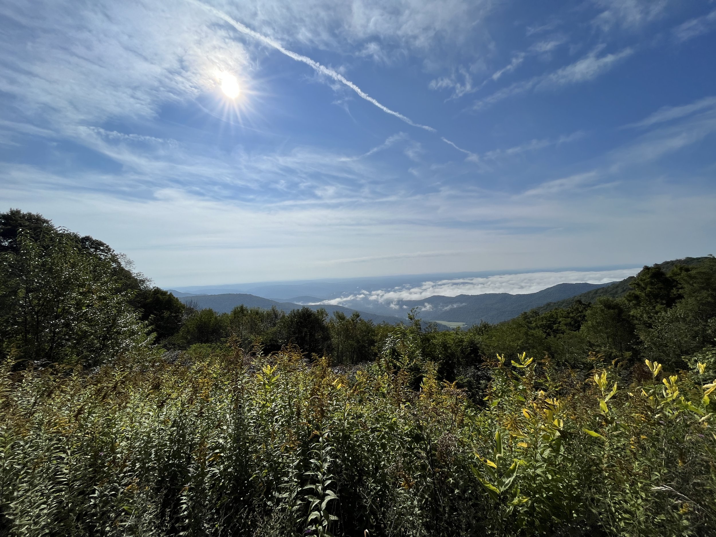
After spending some time at the summit, we headed for the observation tower area that the Cass Scenic Railroad uses as their final stop on their train ride up Bald Knob. The skies were clear with puffy white clouds as the sun set allowing us to get some pretty amazing views looking all the way into Virginia. You can also see the largest radio telescope at Green Bank, WV. In the peace and quiet on top of the mountain, we made dinner and set up our tents for the night.
The forecast for the area was predicting great weather with highs in the low 70s and lows in 40s, which is perfect sleeping weather. I guess Bald Knob doesn’t follow the forecast because shortly after we got in our tents the rain started and pretty much kept going for most of the night.
In the morning, I was hoping to get a spectacular sunrise view of the valleys and ridges below, but the mountain was pretty much in a cloud. I was able to get some very faint views of the far away mountains through small breaks in the clouds providing some eerie early morning views of shaded and blurred mountains with a splash of sunshine peeking through the top of the clouds.
We packed up our wet gear and headed back to Marlinton by taking an old forest service road to the Snowshoe Resort. This portion of the route is part of Bikepacking.com’s Eastern Divide Hellbender route but I have to say it wasn’t much of a road and we ended up pushing our fully loaded bikes through a bunch of rocks and mud for about 3.5 miles until we got to the gravel roads maintained by the resort. After riding on some good gravel and crossing the Cheat River on a newly installed pedestrian/bike bridge, we made it to the Silvercreek Lodge. We took a brief break then rode down the freshly paved Snowshoe Resort Road to the bottom of the valley where the Elk River is just a stream. The ride down was exhilarating as I got to almost 40 miles an hour on my bike.
We stopped for lunch at the Subway at the bottom of the mountain and then tackled a vigorous climb up Linwood Road, which is a nice gravel road ending with a long downhill through a beautiful flowing valley eventually intersecting with the Greenbrier River Trail in Clover Lick.
Loop 2 - The Cranberry
For our second loop, we headed to the Cranberry area with three very strong and long climbs. The two most challenging were multi-mile climbs with one going up to Edray and the other climbing Bishop Knob. After the first two climbs, we followed the Williams River and eventually took a much-needed break at the Tea Creek Campground. We refilled some of our water bottles and enjoyed a fresh wild apple off of the old apple trees that are now part of the campground.
After the break, we continued down the Williams River and eventually met our good buddy Sam Barger, who is a local and has extensive knowledge of the Cranberry area as he has been riding in the area for decades. I met Sam on Strava a few years ago and since then we have ridden together multiple times in Pocahontas, Clay and Tucker counties.
Eventually we had to tackle the last big climb for the day riding uphill multiple miles to reach the summit of Bishop Knob. After resting our legs and lungs for a few, we dropped off of the mountain and started following the Cranberry River upstream. We took our final break at the Cranberry Campground, where I filled all of my bottles of water using the available hand pump in the campground. Waiting till this campground to fill all of the bottles saved me a few pounds of weight that I didn’t have to lug up the climbs we just accomplished.


Just outside of the campground, the road is gated and not accessible by vehicle until you reach the Cranberry Glades in about 20 miles or so. We followed the Cranberry River to the Dogway Camp Shelter, which is a free national forest shelter right on the river. There are several of these shelters along the river and each includes a three-sided log shelter, fire pit, picnic table and a pit toilet. The Dogway site also has a general purpose, size medium, Army tent that an outfitter uses as part of his business. Sam knows the outfitter and said we could sleep in the tent as long as they weren’t using it. We took Sam’s advice as we were able to take advantage of some old Army cots and the tent was large enough to keep our bikes inside.
So how did I know that the tent was an Army general purpose size medium? Well Jay is retired from the Army, so I got the complete rundown on all the uses, benefits and foibles of said tent. I think Jay was at home that night as he gently dozed off in the middle of the Cranberry Wilderness area reminiscing about all of those great times he spent in one of those tents during training in the U.S. and Germany and while on deployment in Iraq.
The best part of using the Army tent was we didn’t have to pack up our damp tents in the morning. I’ve found that at least in the Appalachian Mountains, the tents always seem to be wet in the morning, either from rain, dew or condensation.
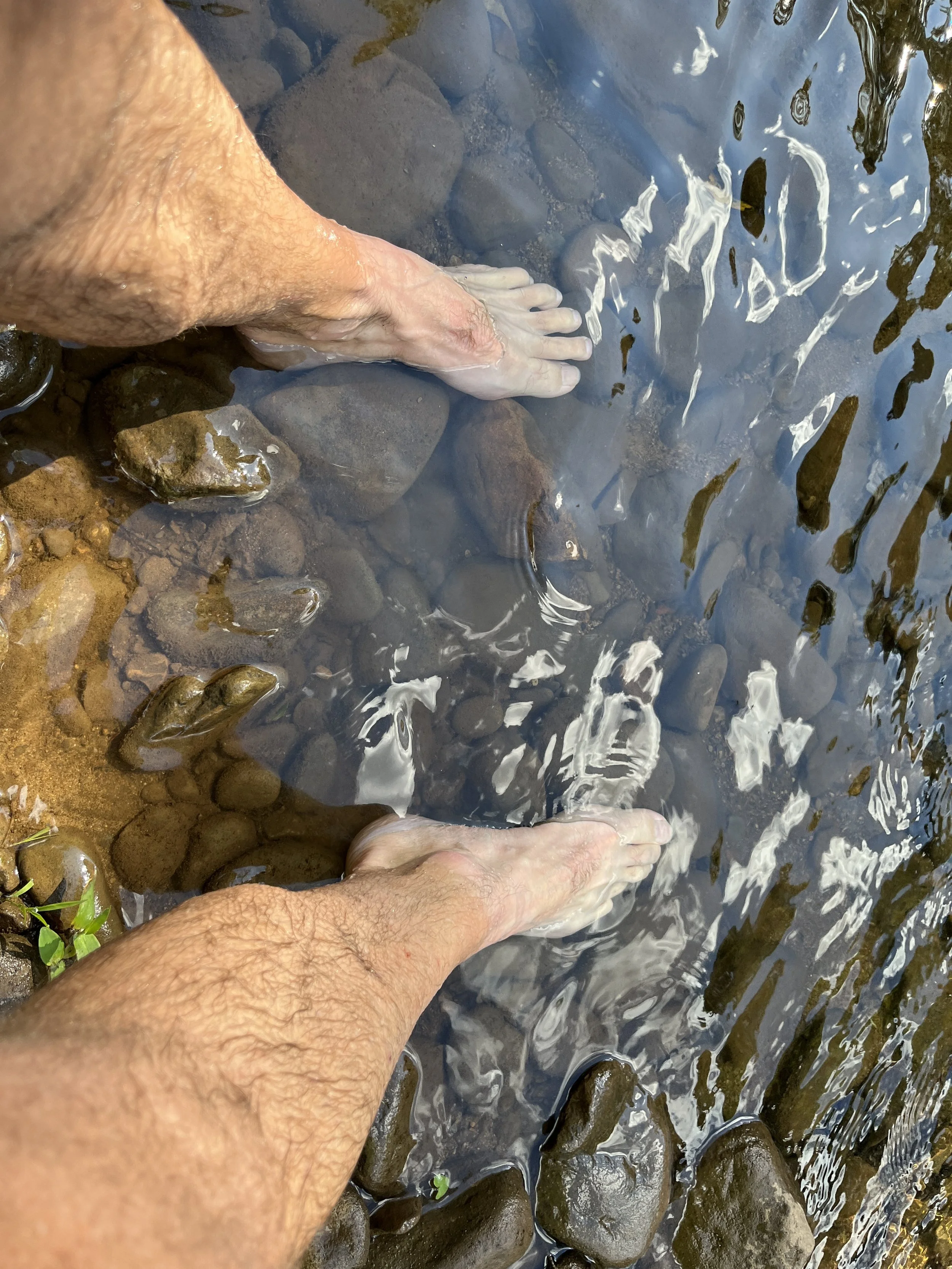
Prior to hitting the sack, we went down to the river and washed our legs in the very cold but also refreshing Cranberry River. We also took some time to follow the very pretty Dogway Creek that spills into the Cranberry near the shelter. Finally, since the Cranberry area has one of the highest densities of bears in West Virginia, we properly hung our food from a tree. We generally do this anytime we are in bear country but knowing the Cranberry area we felt it was extremely important to properly hang our food this night.
We woke up early and headed back to Marlinton and stopped at the Cranberry Glades boardwalk to see the expansive glades in the middle of the valley. Next we had to climb up Rt. 150, the scenic highway, that follows along the top of the Cranberry Wilderness. We climbed up to about 4300 feet where we had some amazing views of the Greenbrier River Valley. We then dropped over the mountain onto a gravel forest service road and pretty much had it downhill all the way back to Marlinton.
Loop 3 - Calvin Price Forest


The third and final loop out of Marlinton was supposed to be a two-day ride through Watoga State Park and the Calvin Price State Forest with overnight camping at Blue Bend campground. However, with the threat of heavy rain all night and the next day due to the arriving tropical storm, we decided to push it and complete the route in one day for a total of 87 miles.
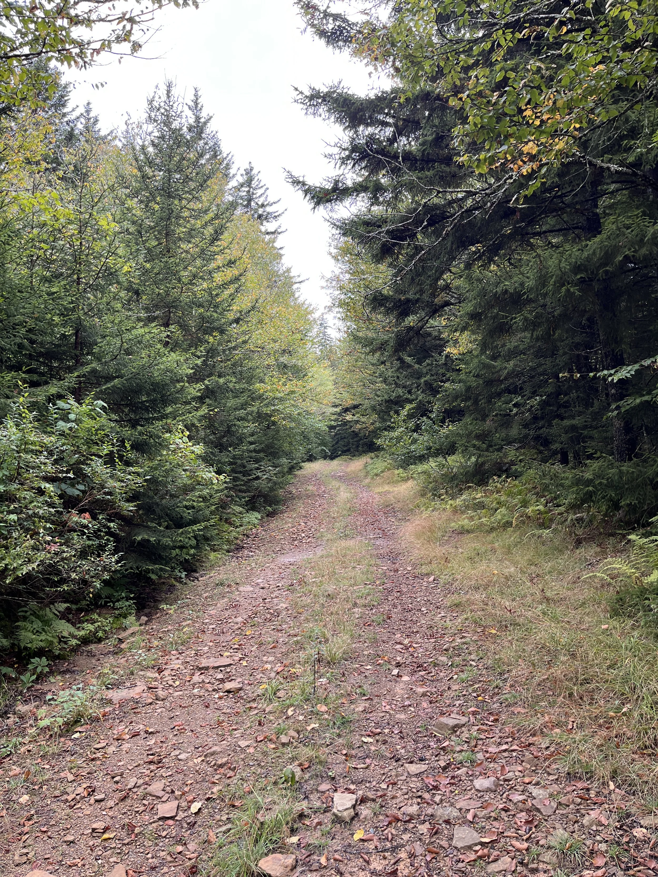
After riding down the Greenbrier Trail and climbing five miles up through Watoga State Park we got to the Laural Creek Campground and entered the most difficult part of the route. The section past the campground in the Calvin Price State Forest is basically a Jeep trail that overlanders use for fun. On our way to this section, we stopped at the Watoga State Park Headquarters and talked to a couple of park rangers to get some sense of the condition of the road. They both said it was passable but there were mud holes that we would have to navigate. They recommended that we take a new timber road that is not on any maps that would get us around the mud road. Their words…
Unfortunately, we couldn’t find the start of the new road so we went with what we knew would get us to the other side of the state forest. 5 miles of hike-a-bike and bushwacking later, we were muddy and pretty beaten up as we finally made our way to some decent gravel roads. We still had about 60 miles to go but our attitude was still good and we had the energy and motivation to push to the end of the route. We ended up crossing eight creeks along the way. I guess it is all part of the adventure…
Jay noted that on our previous days we really hadn’t seen that much wildlife with the exception of a few deer here and there. We were not disappointed on this loop. We saw a lot of deer, turkey, squirrels, hawks and we even saw two ruffed grouse. You normally don’t see too many of these birds, but they presented themselves the way ruffed grouse normally do. They wait until you get close then fly out at a low angle with their wings making loud beating sounds that scare the heck out of you. We never saw a bear, but we did see fresh tracks in the mud that we continuously encountered on this section of this loop. We joked that the rangers must of heard our complaints and moved the wildlife over to our third loop so they could get higher customer satisfaction ratings.
We stopped for a much needed lunch break at the Anthony boat ramp on the Greenbrier River Trail. We both enjoyed a West Virginia classic pepperoni roll, which are perfect bikepacking lunches. They are basically a pizza in a small size that is easy to carry. They were invented by Italian immigrants for the convenience of the coal miners, and they sure do work well for bikepacking. We still had 40 miles of riding on the Greenbrier Trail, so we headed up the river anticipating a smooth and sweet soft-serve ice cream cone at Jack Horner’s Corner store in Seebert. It was about 30 miles away and we continuously talked about it as we made our way along the trail.
We made it to Seebert with both of us starting to lose some energy so the break at Jack Horner’s was very welcomed. We both had the highly anticipated chocolate cone and also got a Diet Mountain Dew. After getting back on our bikes and heading to Marlinton, we agreed that we may had found the magical elixir for energy rejuvenation. Combining the sugar of the ice cream with a nice jolt of caffeine from the soda gave us a great boost of energy and it seemed like the last 10 miles just melted away as we arrived back in Marlinton. We got back to the truck around 6:30PM, loaded our gear and drove the 5+ hours back to our houses in southeast Virginia.
Gear Thoughts
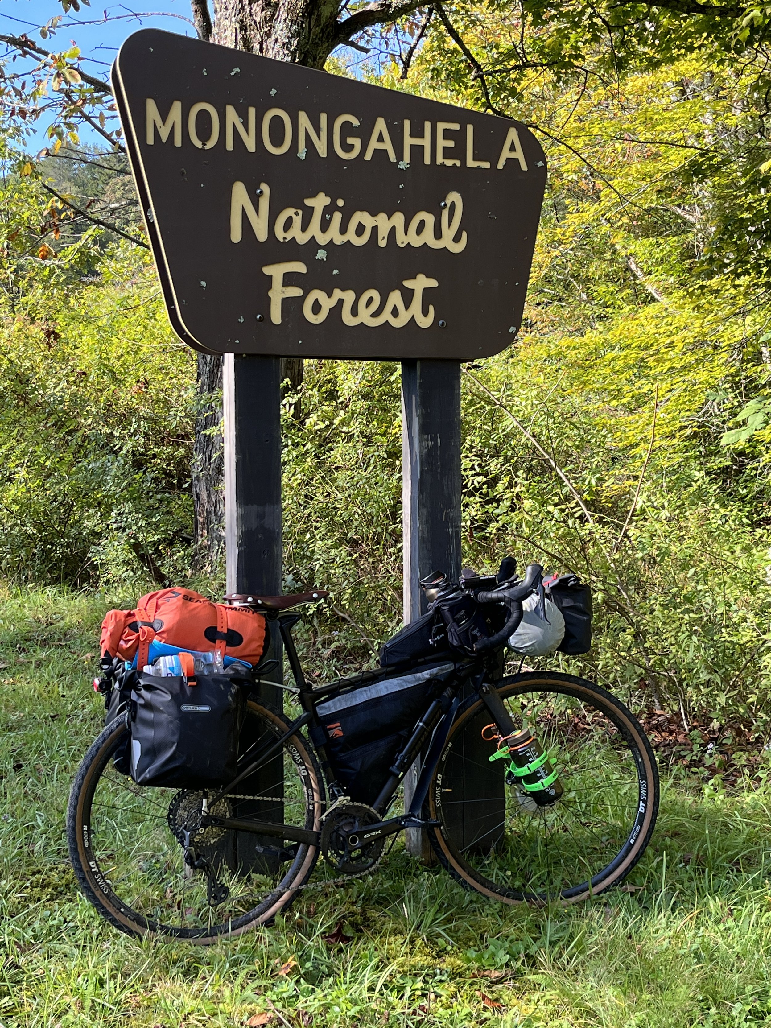
Musguard Mud Guards: I bought a pair of these when the company was still in the Kickstarter phase of their business. I’ve had them for a couple of years but never really did anything with them so I thought I would give the front guard a try during this adventure. I have to say that I was extremely impressed by the performance of this product. The mud guard attaches to the downtube and stays in place with a couple of Velcro straps. I only had one instance where I had to readjust the guard but that was because I lifted the bike and I hit it with my leg. The readjustment took about 5 seconds, and I was off and running again. The guard did an excellent job of reducing the amount of mud and moisture from hitting my frame bag and my legs. It also rolls up into a really small roll so you can easily take it with you and have it available only when you encounter rain or mud. You can learn more about the product at this link and see what they look like on my bike in the picture below.
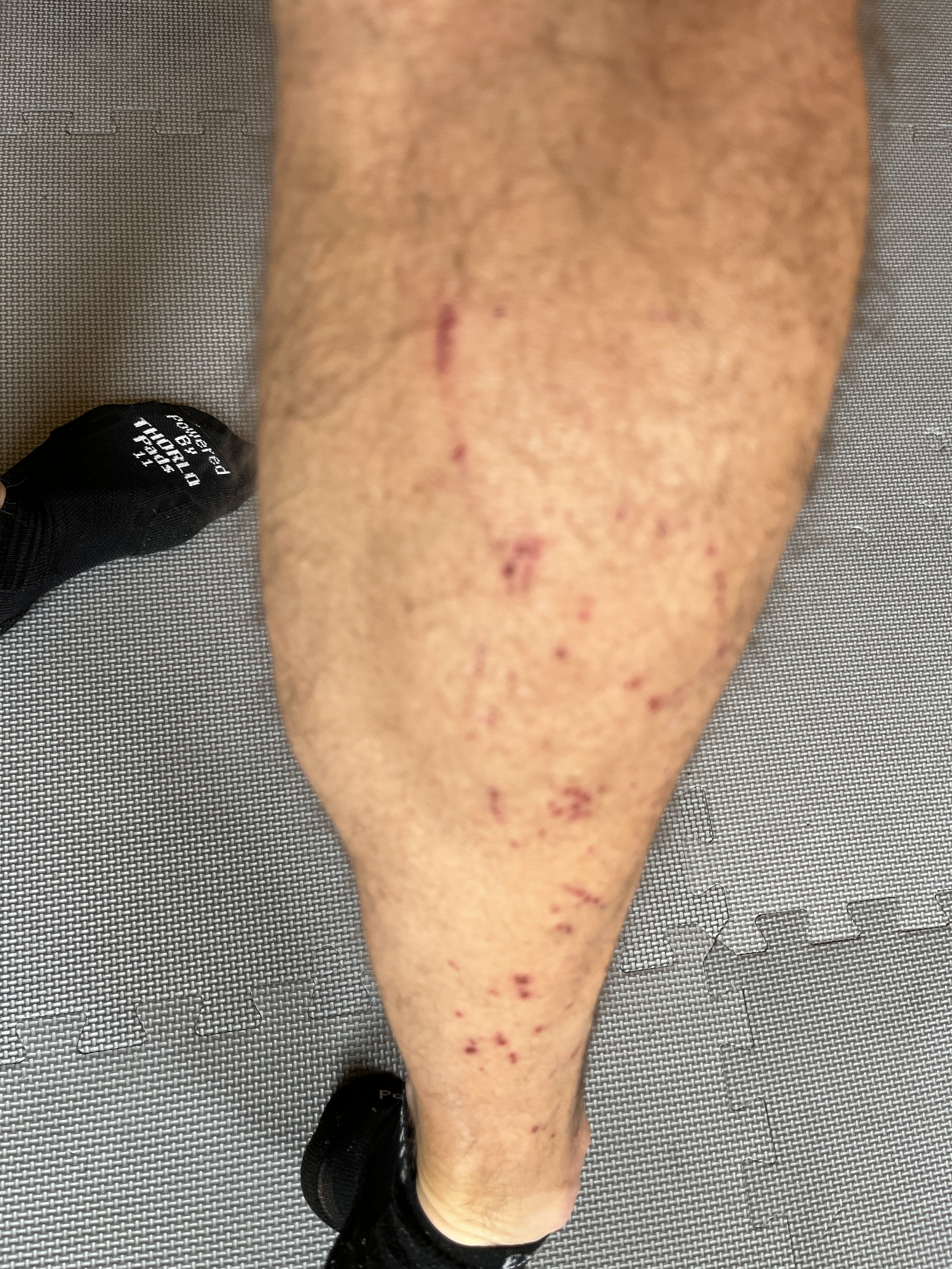
The pain of flat pedals during hike-a-bike: In the past year, I switched from SPD clipless pedals to oversize flat pedals and for gravel riding I really enjoy the flats over the clipless. However, this is the first time that I had to do a lot of hike-a-bike in rugged terrain with my oversize Crankbrothers flat pedals with traction pins. All I can say is ouch! I was continuously smacking the back of my calf with the pedal and the pins just tore up my calf. It eventually looked like a cat had been sharpening their claws on my calf for a few hours. I’m going to keep the flat pedals but if I have to hike-a-bike a lot again, I may try to find a sleave to go over my right calf.