
Recap: Alabama Skyway - Sweet Home Bikepacking
A suburban transcription and mental reclamation of a time and place seemingly, substantially more than a few weeks ago and 570 miles south of this cookie cut home. Though not many mile east of this sprawl, the flora and contour are quite comparable with that land which I drove a day to reach, the subtle variations of varieties, the rusty soil, the onset of spring and several days of sun in the sixties, were all magnified by the magical concoction of soloing and heretofore unknown localities. Simply related, a glorious experience of time is made and balance is strengthened.
This was my first go at bike packing, and sleeplessness, granny gear dreams, sunburn and saddle sores notwithstanding, I intend it’s not my last of such adventures. I’m relatively adept at planning and maintaining comfortable survival, with a willingness to bear the weight burden of such; and generally upheld by a fortuitousness akin to grace – for which I am readily grateful, whether or not such gratitude is a factor in the persistence of this condition. I went with a flexibility and a commitment to remaining thus, no matter the struggle with self-induced objectives of miles or destinations subtly suggested sub-consciously. When I arrived Monday evening, the forecast, which had fully prepared me to ride more than half the time in the rain, came clear that if I were to forego riding Tuesday, I could leave my raingear in the car; thus Tuesday became a fun recon day showing my CR-V to its off-road potential, discovering some abandoned roads allowing me to bypass sections of tarmac, scout campsites and generally gain an imprint on my brain of the lay of the land.


The Talladega National forest is the southern terminus of the Appalachian Range and hosts the highest point in Alabama, Cheaha Mtn at 2411’ and the Skyway Mtwy, which is posted by bikepacking.com as the AL Skyway, running 123 miles from the GA border to the Pinhoti trail southern terminus at Flagg Mtn for 11k of climbing. The southern 20+ miles to get to Flagg Mtn didn’t stand out as I looked at maps and I was thinking I could skip that, ride about 50 miles a day and do the rest North to South and back in 4 days; here’s where my commitment to flexibility and not getting stuck in a ‘have-to’ rut came in to save the trip – remember, this is a vacation, time and space for me to heal and enjoy.
So, Wednesday, under blue skies, with a promisingly sunny forecast, which promise was kept, I shed 2 lb from the bike and prepared to set off from the Eubanks Welcome Ctr, where they kindly provided permission for me to leave my off-road baptized CR-V until Saturday. The welcome center provides not only a friendly welcome, but also complimentary snacks, water, restrooms; and for $3- you can use the house shower when they’re open (I was really looking forward to that by the time I returned). Located in Piedmont, AL along the Chief Ladiga Trail, a rails-to-trail which runs from Anniston, AL northeast to the GA state line where it becomes the Silver Comet Trail and serves in our purposes as a connector in the Southern Highlands Traverse. From bikepacking.com:
“The Alabama Skyway is the final stage of the four-part Southern Highlands Traverse, the fist long distance bikepacking route on the east coast starting in Front Royal, Virginia and finishing at Flagg Mountain, Alabama, at the southern terminus of the Pinhoti Trail. The route traverses a mix of over 1,200 miles of gravel roads, forest double track and plenty of the South’s most challenging single-track.”
Since I didn’t care to put miles on the path, Piedmont was the best juncture for my trip, it being only a few miles west of where the path and road junction, heading south up Duggar Mtn, into the woods, the gravel and dirt, the Skyway. Happily pulling on shorts and short sleeves for my 50 deg departure about 0915h, talking pleasantly with an older man as he rubbed on his sunblock and set up his recumbent, it somehow failed to register in my fair-haired, sunshine deprived brain that I too might be wise to apply sunblock, not that I was packing any – remember, the forecast had little sun foretold. So off I set, into the great, and gratefully not entirely unknown. A few miles of smooth flat path at 600’ elevation, the sounds of frogs & birds, the rundown and unintentional appearance of much of man’s habitations, the harvested cotton fields bearing tatters of the harvest, like thorny ground that ghosts who couldn’t quite hold up their hems had breezed across.
Thirty years ago this youth was drilling holes in cogs, chain rings, brake levers & such for a delightful reduction of grams; these days I scoff in amusement as I browse for bike packing essentials and notice the 29g, 38g & 63g bottle cage choices for $50-, $20 & $5- respectively. Not just to prove my appreciation for the 2 most important technologies brought to bikes in recent years, but with my bike loaded to 60lb & about 18lb on my back, these tubeless 2.1” Kenda Small Block 8’s running 20-22 psi, and mineral oil pumping GRX brakes were glorious facilitator’s of comfort and confidence, inspiring control and reliability.
The conclusion of this account will affirm the positive reciprocity of those many hours, and obtaining more straps, contemplating, organizing and configuring my gear in preparation for what would be 107 miles & 12869’ during 11.5 hours of uninhibited satisfaction. With such preface as you may have just read, the full skinny of this journey as the days went is as follows.
Up from the swampland choirs and cotton fields, ragged as most of man’s making; up, this would be a common combination of letters, up 500’ in 1.5 miles, making 18% grade, then down a long mile and enter the gravel – home. Rusty clay and a sparkling creek rolling along with me, the calling of birds through beech and pine, flittering butterflies up and down we all roll. Switchbacks up to views across the range, through burnt highland by Coleman Lake, a few miles of chip & seal road and back to the gravelly clay and slabs of strafed stone base. Pine Glen campground, a sunny spot by the unencumbered abutment of an old bridge, 1245h, 22 miles, a pleasant picnic spot. Silence, occasionally a buzzing fly nearby or jets and trains in the distance, mostly the wind playing last year’s plants, rustling tapping, rushing on resistance. On we go to refill waters at the ranger station, about 1500h and 30 miles, where tarmac takes over all the way up to Cheaha except for a few miles of earthen alternative. Expansive views of valleys and ranges East and West. A parallel gravel road upon which I was gratefully downhill advantaged over 2 dogs that gave chase; I would not risk this bypass on my return. But then an invitingly gated, abandoned dirt road winding up 400’ gently over 1.5 miles to my Eastern ledge campsite at 1645h; alongside the old road in view of an abandoned fire tower, and relatively sheltered from the wind. A beautiful sunset with colours wafting across the sky, showing the span we’re in followed by a star, then many. The sense of sunburn not diminishing the happy senses of nature, a yummy, warm Indian style dinner; having ridden 39.6 miles, 4864’ and the prospect of sleep (which would be but a dream).


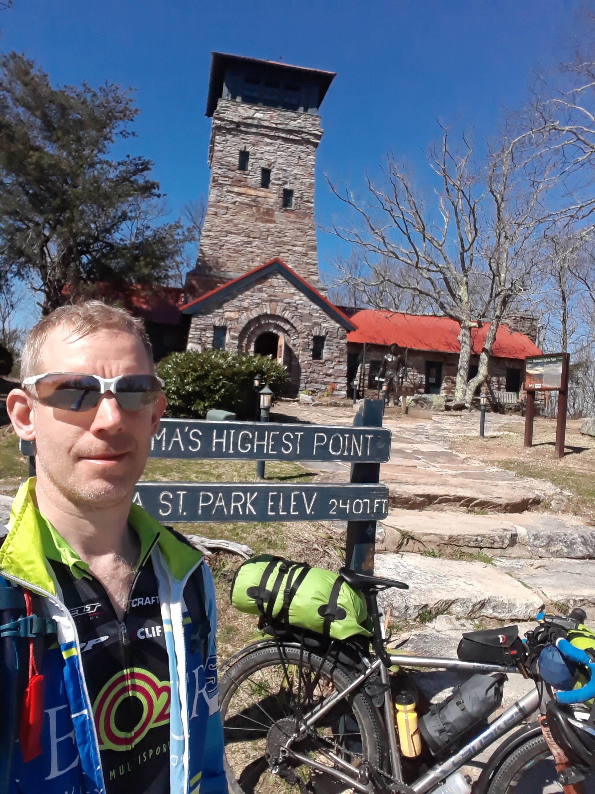
Somewhere before 0600h I rolled over once more and agreed to abandon the pretense of sleep, like a wrecked gambler realizing those are just his own fingers rubbing together and all the chips are gone. The air was near to freezing and I was beginning to shiver, then I remembered I was packing heat, oh happy packets of iron and carbon, these would comfort my toes for hours to come. As cows bellow in the valley below, birds call here to there, light spreading over all, the sun setting precedent, if not the pace for the day, that of coming up. After my favourite camp breakfast of warm quinoa, walnuts, dates and honey, re-packing with some weight redistribution toward the front; about 0915h I set out again. Immediately ahead was 8 miles of pristine, unavoidable tarmac gaining 1k’ in 200-300’ swells until my branch off to Old Cheaha Rd. Having explored a bit on foot during my pre-ride recon, I knew there would be some downed tree navigation, but those first few trees blocking the old road just beyond the gate were much more than an intentionally left discouragement of motorized travel, rather a subtle foreshadowing of the 1.5 miles of desperate hike, drag & heave-a-bike that would bring me 450’ closer to the summit – had I known…and after I did, I would later come back down on the tourist approved highway. The next tarmac bypass however is wonderfully crumbling and slipping away chip & seal banked by rhododendron lining the slope among the mossy angular boulders and bringing one up another 940’ in 2 miles on their own private road with a view; through the road is passable for the cautiously daring motorist I can attest. Back out onto the shadeless tarmac for the final 470’ up another 1.5 miles to the summit, which supports an attractive 75’ high stone lookout tower which was completed by the CCC in the mid-1930’s; fortunately the several hundred foot high antenna next to it is positioned not to interfere with one’s view of the stone tower or the spectacular views from its enclosed observation deck. Arriving here about 1245h, having climbed 2860’ in about 13 miles, I cooked up a full meal of rice & venison jerky and, while savouring such replenishment, I contemplated and recommitted to flexibility. While I can’t exactly say I ‘woke’, I did cease rolling over in my sleeping bag that morning with a reduced interest in camping 2 more nights; I didn’t have to tap any mathematical genius to arrive at the sum (there on the summit) of these matters and set my course back to the North. While it would reach above 70 deg that afternoon, I would wear thin knee sleeves all day and a wind jacket most of the day due to the chill of the wind (especially during descents) and as material sunblock before I had stopped enroute to the summit to contribute my park entrance fee and procure a dusty bottle of double priced sunblock spray. After liberal application and a water refilling, at about 1430h I flew down the road, retracing my route except for the aforementioned section fit only for firewood harvesting. Down at 40 mph, what lasts less than 2 minutes I repay watching my shadow pause the sparkle of the white line for 10 minutes going up. Almost back to last night’s camp with about 24 miles and 3700’, I detoured up to the fire tower when the GPS glitched up to 28 miles and 18700’; this would reconcile next day when the ride uploaded, with the interesting calibration compromise of indicating my max speed at 226.8 mph – must be the average speed needed to drop about 15k’ in 4 miles. Rolling North in the orange blaze cast upon the trees by the setting sun, I headed for a campsite I wouldn’t find, I suspect it’s only accessible via the hiking trail, no sign to it for me; so I pushed on another 6 miles to where I’d had lunch the previous day. Despite legs faded like the daylight and fading faster still, I rolled along while the orange glow spread across the west and purple climbed the eastern sky ultimately sweeping darkness over all. Somewhere in those dusk laden miles my sandals quietly flip-flopped free of the crafty, but not quite competent strapping onto my rack; though I returned partway up the present hill, there was no going back those few or several miles hoping my black sandals would show under my blazing lights – besides, there was no such blaze in my legs to light the pedals. About 1830h I rolled down to Pine Glen campground and deposited my $3- into an envelope and down a metal tube I’m sure is really only for composting honest folks’ cash. I set up, warmed up another Indian meal to soothe my soul and observed that the ride indicated 46.2 miles & 20526’, that too made me feel a bit better about how I felt, like a good magic trick, despite the certain illusion. I hoped that sleep would not be an illusion, began looking forward to paying $3- the next day to shower back at the welcome center; and while the ride really comprised 46.3 miles & 5990’ with a max 20% registered, a decent night’s sleep would also reconcile.


After some actual sleep among the tall pines, other forest trees, spreading stars, rushing water and a gentle moon which greeted my brief waking at 0300h; I awoke finally about 0800h to the sun warming my tent, birds calling, singing and tapping to wake from a chilly night. While some Arnica helped physically, no adequate motivation was restored to retrace last night’s route in an attempt to redeem my sandals; I hope someone finds and puts them to good use. After an easy morning I set out, and yes, up from my creek side camp about 1130h; 22 miles to go. As I came over a rise by Coleman Lake, having been observing the beauty amidst the burned land, I saw work trucks and smoke ahead; perhaps my mask would serve some other purpose. Fortunately the wind was in my favour and no mask was required for me to bask in the warmth (despite the mid-60’s temp, the fire was comforting to me) and watch the flames and a little frog hopping free of a hot fate. I got to talk with a fireman as he drove the perimeter to patrol that which burned contentedly within the confines of the roads dividing; he noted how in Oregon, where he’s from, they have big crews needed to contain such work, it was a friendly fireside conversation. About halfway through the ride I realized I was almost empty of water and wished I hadn’t washed my dishes that morning, or had perhaps caught the tears streaming from my eyes on the downhills; not enough distance left to necessitate a stop to filter water though. As I recall, the pavement had ended about 1.5 miles down from the top of what would be the end of my climbing; I’d never looked forward to getting to the pavement so much as now. Then the blessed reciprocity of sailing down that first climb from the first day. The welcome center, after today’s final 21.8 miles & 2044’, a welcome sight indeed, and it being 1500h I looked forward to testing the capacity of their hot water tank in return for $3- shower privileges, alas, they had closed early – baby wipes it is. But a big, delicious Mexican dinner restored me nonetheless and a couple of hours up to Chattanooga, TN granted the reward of a hotel’s endless hot water to bask in.


Well before shower basking began, the gratitude of such an experience as this trip begat, bore within me a hope and confidence that I will soon endeavor to bask in another bike packing adventure.
